

The history of Global Positioning System traces back to the age of Sputnik, wherein scientists were able to track the satellite with shifts in its radio signal called the “Doppler Effect”. During the mid 1960’s, satellite navigation experiments were done by the United States Navy to track US submarines carrying nuclear missiles. After using six satellites to orbit the poles, this resulted to successful observations of the submarine in detecting changes in Doppler, and pinpointing the submarine’s location in only a few minutes.


Later in the early 1970’s, the Department of Defense saw that the US Navy system might just work with them. The agency considered using the satellites to support their proposed navigation system, which eventually launched NAVSTAR (Navigation System with Timing and Ranging) satellite in 1978. By 1993, the 24-satellite system was already fully operational.
Since then, GPS has been utilized as a multi-use, space-based radio navigation system. It is primarily owned by the US Government and operated by the United States Air Force in meeting their national defense, homeland security, civil, commercial, and scientific requirements.
There are essentially two levels of service of the GPS: the Standard Positioning Service and the Precise Positioning Service. The former is universally available, free of any direct user charges; while the latter is limited for use by the US Armed Forces, US Federal agencies, and selected allied armed forces and governments.
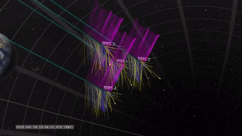
GPS has further developed that it already reached miles and miles away from the Earth’s surface. This is what was done by a NASA mission called the Magnetospheric Multiscale (MMS), which recently achieved a new world record to have the highest altitude fix of a GPS signal.
Four GPS-enabled MMS satellites soared the sky at an altitude of 43,500 miles or about 70,000 kilometers above Earth’s surface. It stayed in vast space in a tight flying formation to survey Earth’s magnetic field, with a primary mission of helping scientists understand the Earth’s magnetosphere, or that orbiting region where Earth’s magnetic field is dominant.
NASA’s Goddard Space Flight Center said in a statement, “The mission uses four individual satellites that fly in a pyramid formation to map magnetic reconnection — a process that occurs as the sun and Earth’s magnetic fields interact.” It added, “Precise GPS tracking allows the satellites to maintain a tight formation and obtain high resolution three-dimensional observations.”

This won’t be the end of the MSS as the NASA scientists look forward to going to a higher orbit. They will seek for a different region of the magnetosphere in spring marking the Phase 2 of the mission. What this means is that their existing world record might just be exceeded, expecting the satellites to reach at least double the previous GPS altitude.
The MMS satellites are not new in the Guinness World Record. They previously made the record of having the closest flying formation between several spacecraft, with only 4.5 miles or 7.24 kilometers in between the four satellites. They also recently hit the books as the fastest-traveling craft to use a GPS receiver at 22,000 mph or 35,405 km/h, at the time the mission was closest to the Earth’s orbit.
NASA explained that the purpose of exploring this magnetic connection is to develop understanding of the different space phenomena, like flares on the sun’s surface and auroras in Earth’s atmosphere.